I wrote a similar post in my old website which can be found here, but I thought I update it and use other tools this time. I believe the old method is still valid.
Why you need a printed scaled plan:
Let’s assume you want your garden as edible as possible. What is possible on your property? What if you ripped out that shed? What about the driveway? How big is my lawn? If there is one big difference between permaculture and gardening, then it’s that permies make a plan and so should you.
It’s a damn bad idea, to sit in front of a screen and try to draw with a program you probably don’t know very well – this is slow bulky and slows the flow of thoughts.
The right way to do it goes like this:
- Print out a scaled plan (this is the annoying part)
- Get your tools as described later.
- Open a bottle of wine (optional)
- Sit around the kitchen table and draw, scribble think and drink (the last is optional).
This process is about thinking from every possible angle. Let the ideas flow, think radical – you can always scale back later. This is about collecting ideas and possibilities, decisions are made later.
Drawing tools needed:
I like to draw with a ballpoint but others prefer pencil, coloured pencils or markers, use what you already have. There are two things you most likely have to buy:
- A triangular scale ruler, which makes measuring easy. This is about $ 18. You don’t need it if you draw in a scale 1:100.
- A roll of transparent tracing paper, the thinnest you can get which is either 22 or 27 gr per m2. This either called whitetrace or sketching paper. Butter paper might work also.
Why you want to print to scale and what are common scales:
Scales make it easy to measure and calculate, that’s all. There are common scales which are 1:100, 1:200, 1:500 or 1:250. Choose a scale which is suitable for the size of your property and you can print out easily.
Print your plan to scale:
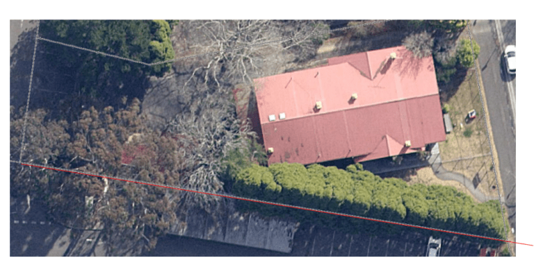
In the old blog post I used google maps as a map, but I discovered sixmaps and they are so much better! There are probably similar map tools outside NSW. Councils usually also have map tools, some have a topographic layer.
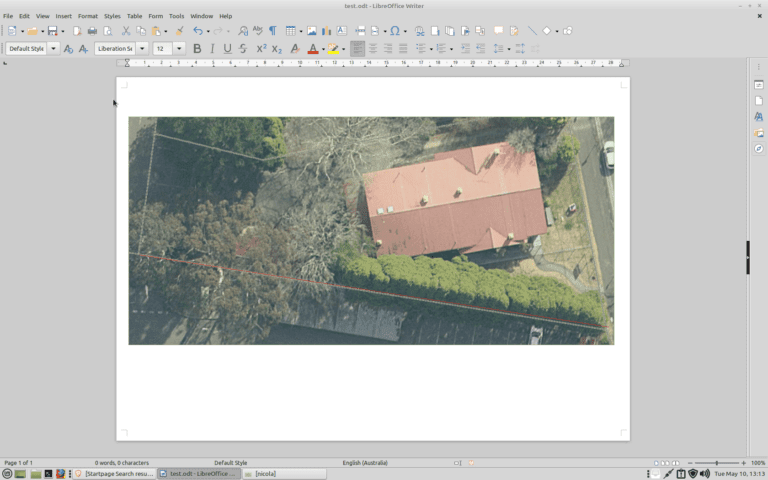
- Search your property on sixmaps, make sure it shows the property boundary. I choose some random public building as an example.
- You can either use the satellite image or the map image or make a printout of both and then manually draw one map.
- Use the measuring tool to measure one long line, this would normally be the longest property boundary. If you use a shorter line it’s likely to be less accurate. In my example the line is 68m.
- Figure out which scale you can print out on your printer, in my case this was 1:250 as I only can print A4. 68m in 1: 250 are 272mm.
- In sixmaps choose the print/pdf tool and generate a pdf. (Make sure that the pop up is not blocked).
- Go over to a writing tool of your choice I used Libre office. Set the page on landscape the margins as narrow as possible.
- Import the pdf, crop it to your property. You might want to rotate it as well.
- Draw a line along the property line you measured. Start exactly at one corner of the property. Try to get this as exact as possible, but let it stick out of imported pdf image. This is important otherwise you will have problems to change the properties of the line it grabs the image instead.
- Click on the line change the properties of the line. Change the length of the line to what it should be in the print, in my case this is 272 mm.
- Now comes the fiddly part: Adjust the image size so that it fits exactly on the line. Take care not to change the line size.
- Print out the image. Make sure that your printer is set to 100%. Measure your print to check.
I believe that this is exact enough for planning your edible garden. Although annoying you do it only once!